|
|
|||||||||||||||||
| Point ID: 9363 | Downloads | Plots | Site Data | Code: 15297610 |
|
|
|||||||||||||||||
| Download | |
|---|---|
| Site Descriptor Information | Site Time Series Data |
| Link to all available data | |
| View: | Time Series | All |
| Units: | mm |
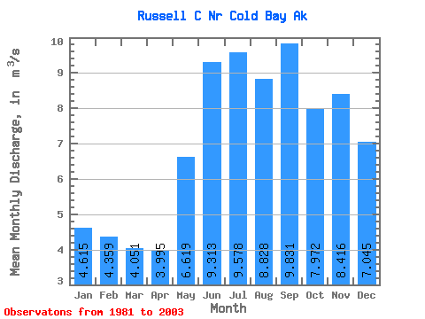
| Statistic | Jan | Feb | Mar | Apr | May | Jun | Jul | Aug | Sep | Oct | Nov | Dec | Annual |
|---|---|---|---|---|---|---|---|---|---|---|---|---|---|
| Mean | 4.62 | 4.36 | 4.05 | 4.00 | 6.62 | 9.31 | 9.58 | 8.83 | 9.83 | 7.97 | 8.42 | 7.04 | 7.13 |
| Standard Deviation | 1.91 | 1.93 | 1.36 | 1.53 | 3.29 | 3.69 | 2.39 | 1.35 | 4.06 | 2.64 | 2.61 | 3.82 | 0.93 |
| Min | 1.69 | 2.02 | 2.15 | 2.27 | 3.78 | 5.88 | 5.45 | 7.24 | 4.82 | 4.87 | 4.77 | 2.46 | 5.43 |
| Max | 9.01 | 7.71 | 6.17 | 7.39 | 16.28 | 17.96 | 14.96 | 11.42 | 15.22 | 14.61 | 15.01 | 15.54 | 8.59 |
| Coefficient of Variation | 0.41 | 0.44 | 0.34 | 0.38 | 0.50 | 0.40 | 0.25 | 0.15 | 0.41 | 0.33 | 0.31 | 0.54 | 0.13 |
 Return to R-Arctic Net Home Page