|
|
|||||||||||||||||
| Point ID: 9363 | Downloads | Plots | Site Data | Code: 15297610 |
|
|
|||||||||||||||||
| Download | |
|---|---|
| Site Descriptor Information | Site Time Series Data |
| Link to all available data | |
| View: | Time Series | All |
| Units: | m3/s |
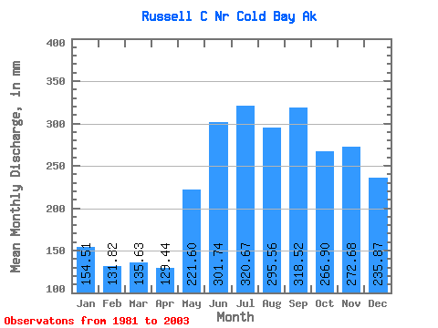
| Statistic | Jan | Feb | Mar | Apr | May | Jun | Jul | Aug | Sep | Oct | Nov | Dec | Annual |
|---|---|---|---|---|---|---|---|---|---|---|---|---|---|
| Mean | 154.47 | 132.96 | 135.60 | 129.42 | 221.57 | 301.75 | 320.63 | 295.51 | 318.54 | 266.86 | 272.69 | 235.82 | 2814.79 |
| Standard Deviation | 63.89 | 58.88 | 45.38 | 49.52 | 110.22 | 119.40 | 80.15 | 45.23 | 131.63 | 88.48 | 84.70 | 127.91 | 367.68 |
| Min | 56.41 | 61.50 | 71.86 | 73.70 | 126.47 | 190.44 | 182.47 | 242.39 | 156.12 | 163.04 | 154.47 | 82.26 | 2141.09 |
| Max | 301.47 | 235.32 | 206.58 | 239.40 | 545.05 | 581.83 | 500.85 | 382.16 | 493.14 | 489.15 | 486.32 | 520.13 | 3388.16 |
| Coefficient of Variation | 0.41 | 0.44 | 0.34 | 0.38 | 0.50 | 0.40 | 0.25 | 0.15 | 0.41 | 0.33 | 0.31 | 0.54 | 0.13 |
 Return to R-Arctic Net Home Page