|
|
|||||||||||||||||
| Point ID: 9346 | Downloads | Plots | Site Data | Code: 15301500 |
|
|
|||||||||||||||||
| Download | |
|---|---|
| Site Descriptor Information | Site Time Series Data |
| Link to all available data | |
| View: | Time Series | All |
| Units: | mm |
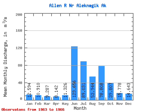
| Statistic | Jan | Feb | Mar | Apr | May | Jun | Jul | Aug | Sep | Oct | Nov | Dec | Annual |
|---|---|---|---|---|---|---|---|---|---|---|---|---|---|
| Mean | 12.59 | 10.91 | 9.29 | 8.14 | 11.33 | 123.66 | 89.03 | 53.94 | 78.81 | 39.81 | 15.78 | 14.64 | 42.29 |
| Standard Deviation | 1.11 | 0.87 | 1.05 | 1.48 | 2.34 | 13.87 | 7.39 | 8.00 | 33.57 | 8.21 | 2.10 | 1.58 | 5.39 |
| Min | 11.33 | 9.91 | 8.49 | 7.22 | 9.60 | 110.44 | 82.36 | 42.26 | 57.75 | 30.33 | 13.53 | 13.03 | 38.48 |
| Max | 13.43 | 11.49 | 10.48 | 9.84 | 13.98 | 137.89 | 98.44 | 60.38 | 128.94 | 44.62 | 17.70 | 16.18 | 46.11 |
| Coefficient of Variation | 0.09 | 0.08 | 0.11 | 0.18 | 0.21 | 0.11 | 0.08 | 0.15 | 0.43 | 0.21 | 0.13 | 0.11 | 0.13 |
 Return to R-Arctic Net Home Page