|
|
| Point ID: 9346 | Downloads | Plots | Site Data | Code: 15301500 |
|
| Download | |
|---|---|
| Site Descriptor Information | Site Time Series Data |
| Link to all available data | |
|
|
|
| View: | Statistics | All |
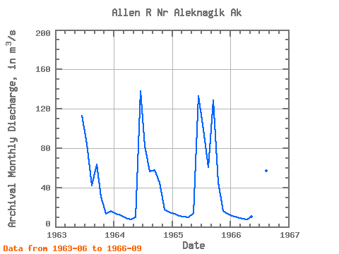
| Units: | mm |
| Year | Jan | Feb | Mar | Apr | May | Jun | Jul | Aug | Sep | Oct | Nov | Dec | Annual | 1963 | 113.16 | 83.98 | 42.26 | 63.41 | 30.33 | 13.53 | 16.18 | 1964 | 13.43 | 11.49 | 8.89 | 7.22 | 9.60 | 137.89 | 82.36 | 56.23 | 57.75 | 44.48 | 17.70 | 14.72 | 38.48 | 1965 | 13.03 | 11.33 | 10.48 | 9.84 | 13.98 | 133.14 | 98.44 | 60.38 | 128.94 | 44.62 | 16.11 | 13.03 | 46.11 | 1966 | 11.33 | 9.91 | 8.49 | 7.36 | 10.39 | 110.44 | 91.34 | 56.91 | 65.13 |
|---|
 Return to R-Arctic Net Home Page