|
|
|||||||||||||||||
| Point ID: 9327 | Downloads | Plots | Site Data | Code: 15064000 |
|
|
|||||||||||||||||
| Download | |
|---|---|
| Site Descriptor Information | Site Time Series Data |
| Link to all available data | |
| View: | Time Series | All |
| Units: | mm |
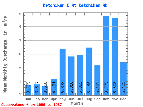
| Statistic | Jan | Feb | Mar | Apr | May | Jun | Jul | Aug | Sep | Oct | Nov | Dec | Annual |
|---|---|---|---|---|---|---|---|---|---|---|---|---|---|
| Mean | 3.79 | 3.82 | 3.67 | 4.18 | 6.37 | 5.82 | 5.96 | 6.47 | 5.19 | 8.78 | 8.60 | 5.42 | 5.81 |
| Standard Deviation | 1.55 | 1.46 | 2.33 | 1.59 | 1.44 | 2.36 | 3.05 | 3.05 | 2.44 | 3.97 | 8.54 | 2.88 | 1.35 |
| Min | 1.35 | 1.98 | 1.54 | 2.69 | 3.54 | 3.12 | 2.38 | 2.77 | 1.79 | 3.04 | 2.83 | 2.17 | 3.59 |
| Max | 7.00 | 6.07 | 8.66 | 8.31 | 8.25 | 9.46 | 10.59 | 12.88 | 9.54 | 15.58 | 33.14 | 11.63 | 8.04 |
| Coefficient of Variation | 0.41 | 0.38 | 0.63 | 0.38 | 0.23 | 0.41 | 0.51 | 0.47 | 0.47 | 0.45 | 0.99 | 0.53 | 0.23 |
 Return to R-Arctic Net Home Page