|
|
|||||||||||||||||
| Point ID: 9327 | Downloads | Plots | Site Data | Code: 15064000 |
|
|
|||||||||||||||||
| Download | |
|---|---|
| Site Descriptor Information | Site Time Series Data |
| Link to all available data | |
| View: | Time Series | All |
| Units: | m3/s |
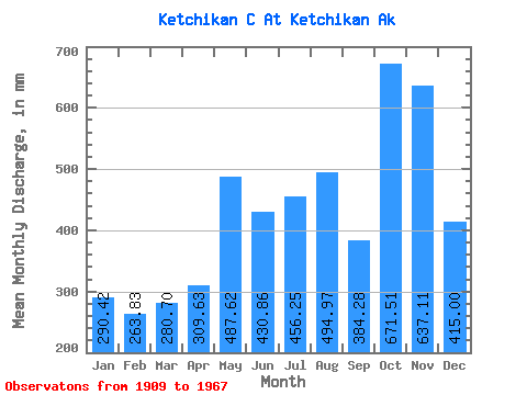
| Statistic | Jan | Feb | Mar | Apr | May | Jun | Jul | Aug | Sep | Oct | Nov | Dec | Annual |
|---|---|---|---|---|---|---|---|---|---|---|---|---|---|
| Mean | 290.37 | 266.13 | 280.66 | 309.61 | 487.57 | 430.89 | 456.18 | 494.90 | 384.29 | 671.39 | 637.15 | 414.95 | 5243.63 |
| Standard Deviation | 118.27 | 101.54 | 178.07 | 117.64 | 109.88 | 174.94 | 233.19 | 233.20 | 180.96 | 303.84 | 632.65 | 220.38 | 1220.79 |
| Min | 103.66 | 138.17 | 117.55 | 199.57 | 270.61 | 231.44 | 181.80 | 211.86 | 132.74 | 232.74 | 209.69 | 165.79 | 3239.68 |
| Max | 536.00 | 423.34 | 662.50 | 615.76 | 631.41 | 700.21 | 810.36 | 985.89 | 706.29 | 1191.93 | 2453.99 | 889.65 | 7248.61 |
| Coefficient of Variation | 0.41 | 0.38 | 0.63 | 0.38 | 0.23 | 0.41 | 0.51 | 0.47 | 0.47 | 0.45 | 0.99 | 0.53 | 0.23 |
 Return to R-Arctic Net Home Page