|
|
|||||||||||||||||
| Point ID: 9288 | Downloads | Plots | Site Data | Code: 15260000 |
|
|
|||||||||||||||||
| Download | |
|---|---|
| Site Descriptor Information | Site Time Series Data |
| Link to all available data | |
| View: | Time Series | All |
| Units: | mm |
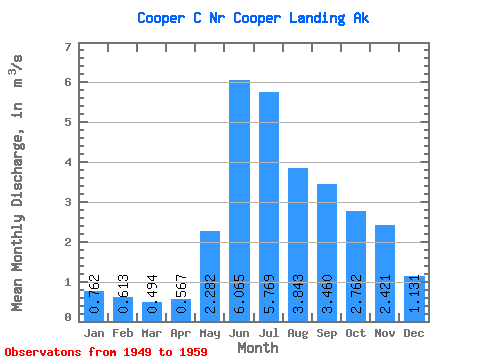
| Statistic | Jan | Feb | Mar | Apr | May | Jun | Jul | Aug | Sep | Oct | Nov | Dec | Annual |
|---|---|---|---|---|---|---|---|---|---|---|---|---|---|
| Mean | 0.76 | 0.61 | 0.49 | 0.57 | 2.28 | 6.07 | 5.77 | 3.84 | 3.46 | 2.76 | 2.42 | 1.13 | 2.51 |
| Standard Deviation | 0.29 | 0.27 | 0.17 | 0.22 | 1.02 | 2.33 | 2.08 | 1.07 | 1.25 | 1.48 | 1.76 | 0.49 | 0.54 |
| Min | 0.38 | 0.34 | 0.26 | 0.33 | 0.82 | 3.90 | 3.43 | 2.19 | 1.96 | 1.28 | 0.85 | 0.57 | 1.90 |
| Max | 1.35 | 1.29 | 0.89 | 0.91 | 3.89 | 11.66 | 9.48 | 5.27 | 6.12 | 5.89 | 5.39 | 2.12 | 3.65 |
| Coefficient of Variation | 0.38 | 0.44 | 0.34 | 0.39 | 0.45 | 0.38 | 0.36 | 0.28 | 0.36 | 0.54 | 0.73 | 0.44 | 0.21 |
 Return to R-Arctic Net Home Page