|
|
|||||||||||||||||
| Point ID: 9288 | Downloads | Plots | Site Data | Code: 15260000 |
|
|
|||||||||||||||||
| Download | |
|---|---|
| Site Descriptor Information | Site Time Series Data |
| Link to all available data | |
| View: | Time Series | All |
| Units: | m3/s |
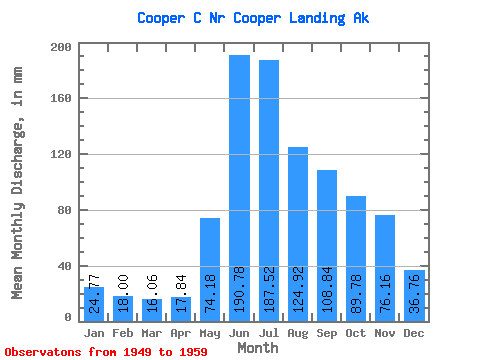
| Statistic | Jan | Feb | Mar | Apr | May | Jun | Jul | Aug | Sep | Oct | Nov | Dec | Annual |
|---|---|---|---|---|---|---|---|---|---|---|---|---|---|
| Mean | 24.78 | 18.16 | 16.06 | 17.83 | 74.17 | 190.79 | 187.49 | 124.89 | 108.85 | 89.78 | 76.16 | 36.76 | 961.90 |
| Standard Deviation | 9.42 | 8.00 | 5.47 | 6.93 | 33.16 | 73.32 | 67.46 | 34.77 | 39.34 | 48.22 | 55.28 | 16.02 | 205.79 |
| Min | 12.40 | 10.18 | 8.40 | 10.24 | 26.57 | 122.57 | 111.41 | 71.08 | 61.70 | 41.71 | 26.74 | 18.41 | 727.09 |
| Max | 43.89 | 38.18 | 28.86 | 28.50 | 126.47 | 366.93 | 308.04 | 171.41 | 192.40 | 191.42 | 169.54 | 68.87 | 1396.55 |
| Coefficient of Variation | 0.38 | 0.44 | 0.34 | 0.39 | 0.45 | 0.38 | 0.36 | 0.28 | 0.36 | 0.54 | 0.73 | 0.44 | 0.21 |
 Return to R-Arctic Net Home Page