|
|
|||||||||||||||||
| Point ID: 9274 | Downloads | Plots | Site Data | Code: 15020100 |
|
|
|||||||||||||||||
| Download | |
|---|---|
| Site Descriptor Information | Site Time Series Data |
| Link to all available data | |
| View: | Time Series | All |
| Units: | mm |
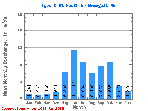
| Statistic | Jan | Feb | Mar | Apr | May | Jun | Jul | Aug | Sep | Oct | Nov | Dec | Annual |
|---|---|---|---|---|---|---|---|---|---|---|---|---|---|
| Mean | 1.24 | 0.96 | 1.17 | 1.62 | 6.21 | 11.42 | 8.68 | 6.10 | 7.67 | 8.69 | 3.02 | 1.82 | 4.95 |
| Standard Deviation | 0.81 | 0.47 | 0.90 | 0.60 | 1.62 | 1.82 | 0.55 | 1.99 | 3.49 | 2.37 | 1.06 | 0.79 | 0.36 |
| Min | 0.38 | 0.36 | 0.31 | 0.65 | 4.26 | 8.97 | 8.07 | 2.96 | 3.07 | 6.29 | 1.70 | 1.08 | 4.48 |
| Max | 2.54 | 1.45 | 2.84 | 2.17 | 8.05 | 13.98 | 9.62 | 8.85 | 12.32 | 12.32 | 4.39 | 3.22 | 5.43 |
| Coefficient of Variation | 0.65 | 0.49 | 0.77 | 0.37 | 0.26 | 0.16 | 0.06 | 0.33 | 0.46 | 0.27 | 0.35 | 0.43 | 0.07 |
 Return to R-Arctic Net Home Page