|
|
| Point ID: 9274 | Downloads | Plots | Site Data | Code: 15020100 |
|
| Download | |
|---|---|
| Site Descriptor Information | Site Time Series Data |
| Link to all available data | |
|
|
|
| View: | Statistics | All |
| Units: | mm |
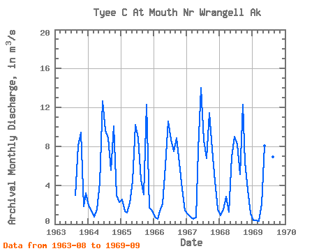
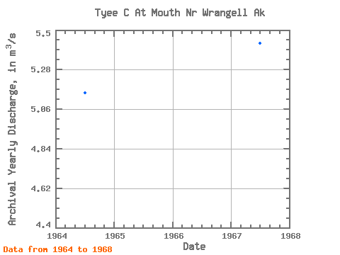
| Year | Jan | Feb | Mar | Apr | May | Jun | Jul | Aug | Sep | Oct | Nov | Dec | Annual | 1963 | 2.96 | 8.06 | 9.42 | 1.84 | 3.22 | 1964 | 1.89 | 1.38 | 0.76 | 1.53 | 4.26 | 12.66 | 9.62 | 8.85 | 5.58 | 10.06 | 3.01 | 2.23 | 5.15 | 1965 | 2.54 | 1.31 | 1.19 | 2.17 | 4.38 | 10.24 | 8.87 | 4.56 | 3.07 | 12.32 | 1.70 | 1.42 | 4.48 | 1966 | 0.73 | 0.53 | 1.35 | 2.12 | 5.97 | 10.59 | 8.68 | 7.50 | 8.84 | 6.29 | 3.61 | 1.42 | 4.80 | 1967 | 1.03 | 0.74 | 0.57 | 0.65 | 7.65 | 13.98 | 8.64 | 6.80 | 11.42 | 7.71 | 4.39 | 1.55 | 5.43 | 1968 | 0.88 | 1.45 | 2.84 | 1.22 | 6.93 | 8.97 | 8.23 | 5.12 | 12.32 | 6.31 | 3.57 | 1.08 | 4.91 | 1969 | 0.38 | 0.36 | 0.31 | 2.04 | 8.05 | 12.06 | 8.07 | 6.92 | 4.42 |
|---|
 Return to R-Arctic Net Home Page