|
|
|||||||||||||||||
| Point ID: 9228 | Downloads | Plots | Site Data | Code: 15216000 |
|
|
|||||||||||||||||
| Download | |
|---|---|
| Site Descriptor Information | Site Time Series Data |
| Link to all available data | |
| View: | Time Series | All |
| Units: | mm |
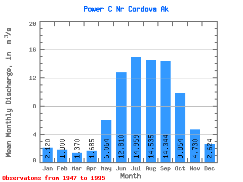
| Statistic | Jan | Feb | Mar | Apr | May | Jun | Jul | Aug | Sep | Oct | Nov | Dec | Annual |
|---|---|---|---|---|---|---|---|---|---|---|---|---|---|
| Mean | 2.12 | 1.80 | 1.37 | 1.69 | 6.06 | 12.81 | 14.96 | 14.54 | 14.34 | 9.85 | 4.73 | 2.62 | 7.20 |
| Standard Deviation | 1.58 | 1.35 | 0.87 | 0.91 | 2.20 | 2.60 | 3.22 | 4.47 | 5.85 | 4.62 | 2.82 | 1.45 | 1.18 |
| Min | 0.71 | 0.54 | 0.44 | 0.45 | 2.66 | 9.29 | 9.97 | 7.15 | 6.17 | 3.49 | 1.37 | 1.00 | 4.92 |
| Max | 9.95 | 7.26 | 3.80 | 4.60 | 13.26 | 22.73 | 26.20 | 36.51 | 29.00 | 30.14 | 15.53 | 7.07 | 10.73 |
| Coefficient of Variation | 0.74 | 0.75 | 0.63 | 0.54 | 0.36 | 0.20 | 0.21 | 0.31 | 0.41 | 0.47 | 0.60 | 0.55 | 0.16 |
 Return to R-Arctic Net Home Page