|
|
|||||||||||||||||
| Point ID: 9228 | Downloads | Plots | Site Data | Code: 15216000 |
|
|
|||||||||||||||||
| Download | |
|---|---|
| Site Descriptor Information | Site Time Series Data |
| Link to all available data | |
| View: | Time Series | All |
| Units: | m3/s |
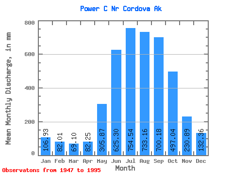
| Statistic | Jan | Feb | Mar | Apr | May | Jun | Jul | Aug | Sep | Oct | Nov | Dec | Annual |
|---|---|---|---|---|---|---|---|---|---|---|---|---|---|
| Mean | 106.92 | 82.69 | 69.11 | 82.26 | 305.82 | 625.29 | 754.41 | 733.04 | 700.21 | 496.94 | 230.91 | 132.34 | 4281.76 |
| Standard Deviation | 79.64 | 61.94 | 43.81 | 44.35 | 110.98 | 127.11 | 162.48 | 225.56 | 285.48 | 233.04 | 137.65 | 73.10 | 703.10 |
| Min | 35.71 | 24.77 | 22.12 | 21.76 | 134.29 | 453.75 | 502.72 | 360.53 | 301.24 | 176.07 | 66.81 | 50.50 | 2924.20 |
| Max | 501.82 | 333.80 | 191.64 | 224.34 | 668.91 | 1109.47 | 1321.60 | 1841.11 | 1415.60 | 1519.78 | 757.88 | 356.29 | 6376.49 |
| Coefficient of Variation | 0.74 | 0.75 | 0.63 | 0.54 | 0.36 | 0.20 | 0.21 | 0.31 | 0.41 | 0.47 | 0.60 | 0.55 | 0.16 |
 Return to R-Arctic Net Home Page