|
|
|||||||||||||||||
| Point ID: 9170 | Downloads | Plots | Site Data | Code: 15129600 |
|
|
|||||||||||||||||
| Download | |
|---|---|
| Site Descriptor Information | Site Time Series Data |
| Link to all available data | |
| View: | Time Series | All |
| Units: | mm |
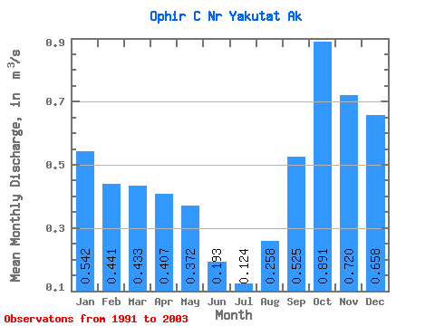
| Statistic | Jan | Feb | Mar | Apr | May | Jun | Jul | Aug | Sep | Oct | Nov | Dec | Annual |
|---|---|---|---|---|---|---|---|---|---|---|---|---|---|
| Mean | 0.54 | 0.44 | 0.43 | 0.41 | 0.37 | 0.19 | 0.12 | 0.26 | 0.53 | 0.89 | 0.72 | 0.66 | 0.47 |
| Standard Deviation | 0.31 | 0.27 | 0.30 | 0.21 | 0.23 | 0.14 | 0.06 | 0.18 | 0.22 | 0.37 | 0.28 | 0.34 | 0.12 |
| Min | 0.14 | 0.09 | 0.12 | 0.08 | 0.15 | 0.06 | 0.02 | 0.04 | 0.17 | 0.58 | 0.36 | 0.25 | 0.28 |
| Max | 1.21 | 1.01 | 1.08 | 0.80 | 0.97 | 0.56 | 0.27 | 0.55 | 0.87 | 1.72 | 1.24 | 1.39 | 0.66 |
| Coefficient of Variation | 0.57 | 0.60 | 0.69 | 0.53 | 0.61 | 0.73 | 0.47 | 0.69 | 0.41 | 0.41 | 0.39 | 0.52 | 0.26 |
 Return to R-Arctic Net Home Page