|
|
|||||||||||||||||
| Point ID: 9170 | Downloads | Plots | Site Data | Code: 15129600 |
|
|
|||||||||||||||||
| Download | |
|---|---|
| Site Descriptor Information | Site Time Series Data |
| Link to all available data | |
| View: | Time Series | All |
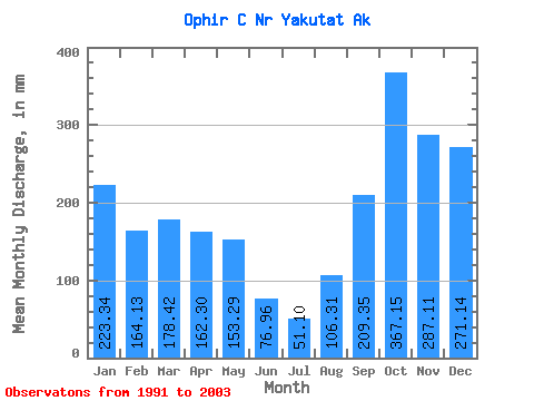
| Units: | m3/s |
| Statistic | Jan | Feb | Mar | Apr | May | Jun | Jul | Aug | Sep | Oct | Nov | Dec | Annual |
|---|---|---|---|---|---|---|---|---|---|---|---|---|---|
| Mean | 223.47 | 165.62 | 178.23 | 162.11 | 153.45 | 76.80 | 51.05 | 106.30 | 209.18 | 367.02 | 287.31 | 271.08 | 2281.24 |
| Standard Deviation | 127.85 | 99.78 | 123.62 | 85.68 | 94.01 | 56.22 | 23.94 | 73.61 | 86.22 | 151.59 | 110.67 | 140.34 | 596.26 |
| Min | 59.86 | 35.17 | 48.20 | 30.23 | 61.38 | 22.61 | 7.83 | 15.40 | 66.63 | 238.60 | 141.84 | 104.59 | 1339.30 |
| Max | 498.29 | 381.16 | 447.10 | 319.96 | 401.17 | 222.14 | 112.89 | 226.45 | 348.20 | 708.29 | 494.19 | 572.41 | 3202.20 |
| Coefficient of Variation | 0.57 | 0.60 | 0.69 | 0.53 | 0.61 | 0.73 | 0.47 | 0.69 | 0.41 | 0.41 | 0.39 | 0.52 | 0.26 |
 Return to R-Arctic Net Home Page