|
|
|||||||||||||||||
| Point ID: 9157 | Downloads | Plots | Site Data | Code: 15108600 |
|
|
|||||||||||||||||
| Download | |
|---|---|
| Site Descriptor Information | Site Time Series Data |
| Link to all available data | |
| View: | Time Series | All |
| Units: | mm |
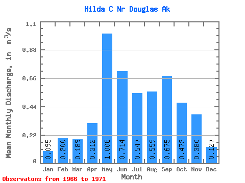
| Statistic | Jan | Feb | Mar | Apr | May | Jun | Jul | Aug | Sep | Oct | Nov | Dec | Annual |
|---|---|---|---|---|---|---|---|---|---|---|---|---|---|
| Mean | 0.10 | 0.20 | 0.19 | 0.31 | 1.01 | 0.71 | 0.55 | 0.56 | 0.68 | 0.47 | 0.38 | 0.13 | 0.44 |
| Standard Deviation | 0.07 | 0.15 | 0.13 | 0.08 | 0.39 | 0.45 | 0.14 | 0.17 | 0.33 | 0.22 | 0.25 | 0.07 | 0.11 |
| Min | 0.02 | 0.01 | 0.06 | 0.21 | 0.76 | 0.25 | 0.34 | 0.33 | 0.35 | 0.17 | 0.17 | 0.07 | 0.36 |
| Max | 0.20 | 0.41 | 0.36 | 0.43 | 1.68 | 1.26 | 0.74 | 0.79 | 1.10 | 0.70 | 0.75 | 0.22 | 0.60 |
| Coefficient of Variation | 0.71 | 0.73 | 0.68 | 0.26 | 0.39 | 0.62 | 0.26 | 0.30 | 0.48 | 0.47 | 0.67 | 0.52 | 0.26 |
 Return to R-Arctic Net Home Page