|
|
|||||||||||||||||
| Point ID: 9157 | Downloads | Plots | Site Data | Code: 15108600 |
|
|
|||||||||||||||||
| Download | |
|---|---|
| Site Descriptor Information | Site Time Series Data |
| Link to all available data | |
| View: | Time Series | All |
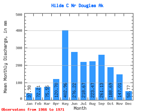
| Units: | m3/s |
| Statistic | Jan | Feb | Mar | Apr | May | Jun | Jul | Aug | Sep | Oct | Nov | Dec | Annual |
|---|---|---|---|---|---|---|---|---|---|---|---|---|---|
| Mean | 38.16 | 72.85 | 75.52 | 120.64 | 402.97 | 276.31 | 218.72 | 223.26 | 261.20 | 188.46 | 147.08 | 50.84 | 2053.04 |
| Standard Deviation | 26.95 | 53.37 | 50.95 | 31.16 | 157.29 | 172.75 | 57.02 | 67.36 | 125.55 | 89.46 | 97.80 | 26.16 | 535.75 |
| Min | 7.63 | 5.20 | 25.17 | 83.02 | 303.98 | 95.25 | 137.90 | 132.30 | 137.14 | 68.83 | 66.40 | 26.59 | 1675.46 |
| Max | 77.81 | 148.62 | 145.49 | 165.99 | 670.66 | 487.10 | 296.18 | 314.76 | 424.73 | 280.42 | 289.14 | 87.69 | 2847.72 |
| Coefficient of Variation | 0.71 | 0.73 | 0.68 | 0.26 | 0.39 | 0.62 | 0.26 | 0.30 | 0.48 | 0.47 | 0.67 | 0.52 | 0.26 |
 Return to R-Arctic Net Home Page