|
|
|||||||||||||||||
| Point ID: 9156 | Downloads | Plots | Site Data | Code: 15107920 |
|
|
|||||||||||||||||
| Download | |
|---|---|
| Site Descriptor Information | Site Time Series Data |
| Link to all available data | |
| View: | Time Series | All |
| Units: | mm |
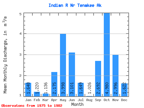
| Statistic | Jan | Feb | Mar | Apr | May | Jun | Jul | Aug | Sep | Oct | Nov | Dec | Annual |
|---|---|---|---|---|---|---|---|---|---|---|---|---|---|
| Mean | 1.65 | 1.22 | 1.14 | 2.17 | 4.00 | 3.10 | 1.65 | 1.03 | 2.69 | 4.98 | 3.00 | 1.62 | 2.46 |
| Standard Deviation | 1.42 | 1.01 | 0.40 | 0.71 | 1.16 | 1.47 | 0.80 | 0.54 | 1.50 | 2.00 | 1.21 | 0.77 | 0.40 |
| Min | 0.51 | 0.20 | 0.53 | 1.11 | 2.48 | 1.52 | 0.86 | 0.53 | 1.56 | 2.19 | 1.22 | 0.40 | 2.02 |
| Max | 4.62 | 3.30 | 1.78 | 2.88 | 6.02 | 6.07 | 3.30 | 2.11 | 5.09 | 8.10 | 4.21 | 2.52 | 3.20 |
| Coefficient of Variation | 0.86 | 0.83 | 0.35 | 0.33 | 0.29 | 0.47 | 0.49 | 0.53 | 0.56 | 0.40 | 0.41 | 0.48 | 0.16 |
 Return to R-Arctic Net Home Page