|
|
|||||||||||||||||
| Point ID: 9156 | Downloads | Plots | Site Data | Code: 15107920 |
|
|
|||||||||||||||||
| Download | |
|---|---|
| Site Descriptor Information | Site Time Series Data |
| Link to all available data | |
| View: | Time Series | All |
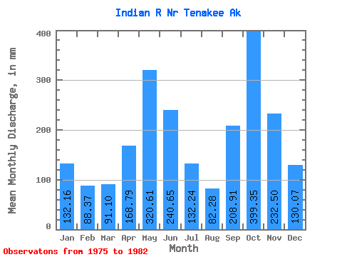
| Units: | m3/s |
| Statistic | Jan | Feb | Mar | Apr | May | Jun | Jul | Aug | Sep | Oct | Nov | Dec | Annual |
|---|---|---|---|---|---|---|---|---|---|---|---|---|---|
| Mean | 132.15 | 89.14 | 91.08 | 168.76 | 320.55 | 240.64 | 132.25 | 82.29 | 208.91 | 399.26 | 232.47 | 130.09 | 2328.83 |
| Standard Deviation | 114.09 | 74.06 | 32.03 | 55.02 | 92.92 | 114.15 | 64.47 | 43.19 | 116.59 | 160.14 | 94.13 | 61.91 | 380.44 |
| Min | 40.87 | 14.24 | 42.26 | 86.00 | 199.13 | 117.71 | 68.79 | 42.63 | 120.72 | 175.62 | 95.01 | 32.11 | 1907.06 |
| Max | 370.81 | 241.37 | 142.89 | 223.42 | 483.02 | 471.07 | 264.75 | 169.18 | 394.68 | 649.64 | 327.06 | 201.62 | 3024.04 |
| Coefficient of Variation | 0.86 | 0.83 | 0.35 | 0.33 | 0.29 | 0.47 | 0.49 | 0.53 | 0.56 | 0.40 | 0.41 | 0.48 | 0.16 |
 Return to R-Arctic Net Home Page