|
|
|||||||||||||||||
| Point ID: 9142 | Downloads | Plots | Site Data | Code: 15106940 |
|
|
|||||||||||||||||
| Download | |
|---|---|
| Site Descriptor Information | Site Time Series Data |
| Link to all available data | |
| View: | Time Series | All |
| Units: | mm |
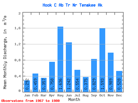
| Statistic | Jan | Feb | Mar | Apr | May | Jun | Jul | Aug | Sep | Oct | Nov | Dec | Annual |
|---|---|---|---|---|---|---|---|---|---|---|---|---|---|
| Mean | 0.29 | 0.46 | 0.36 | 0.76 | 1.64 | 1.24 | 0.55 | 0.38 | 0.83 | 1.59 | 0.99 | 0.53 | 0.81 |
| Standard Deviation | 0.19 | 0.45 | 0.17 | 0.30 | 0.48 | 0.57 | 0.26 | 0.20 | 0.26 | 0.94 | 0.53 | 0.39 | 0.14 |
| Min | 0.09 | 0.06 | 0.12 | 0.19 | 0.81 | 0.42 | 0.17 | 0.10 | 0.53 | 0.61 | 0.22 | 0.13 | 0.56 |
| Max | 0.77 | 1.60 | 0.65 | 1.21 | 2.21 | 2.11 | 0.95 | 0.72 | 1.28 | 3.96 | 1.80 | 1.12 | 1.03 |
| Coefficient of Variation | 0.64 | 0.97 | 0.49 | 0.40 | 0.29 | 0.46 | 0.47 | 0.53 | 0.31 | 0.59 | 0.53 | 0.73 | 0.17 |
 Return to R-Arctic Net Home Page