|
|
|||||||||||||||||
| Point ID: 9142 | Downloads | Plots | Site Data | Code: 15106940 |
|
|
|||||||||||||||||
| Download | |
|---|---|
| Site Descriptor Information | Site Time Series Data |
| Link to all available data | |
| View: | Time Series | All |
| Units: | m3/s |
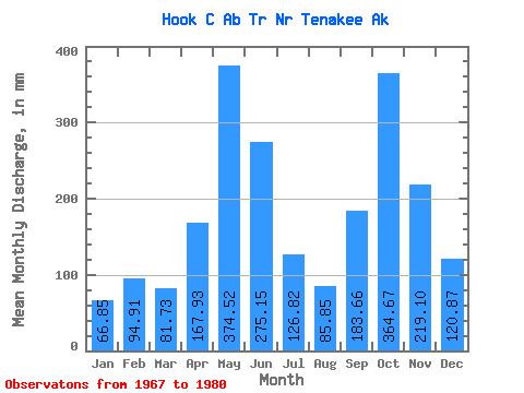
| Statistic | Jan | Feb | Mar | Apr | May | Jun | Jul | Aug | Sep | Oct | Nov | Dec | Annual |
|---|---|---|---|---|---|---|---|---|---|---|---|---|---|
| Mean | 66.85 | 95.71 | 81.63 | 167.82 | 374.57 | 275.09 | 126.84 | 85.75 | 183.70 | 364.59 | 219.10 | 120.83 | 2179.55 |
| Standard Deviation | 42.58 | 93.00 | 39.76 | 67.64 | 109.48 | 126.35 | 59.35 | 45.27 | 57.21 | 216.27 | 116.73 | 88.56 | 368.14 |
| Min | 20.41 | 13.32 | 28.50 | 41.96 | 184.20 | 92.13 | 38.00 | 22.34 | 116.48 | 140.36 | 48.27 | 28.91 | 1509.17 |
| Max | 175.41 | 334.08 | 149.42 | 267.81 | 506.60 | 467.98 | 218.59 | 164.50 | 283.28 | 906.99 | 398.33 | 257.57 | 2784.03 |
| Coefficient of Variation | 0.64 | 0.97 | 0.49 | 0.40 | 0.29 | 0.46 | 0.47 | 0.53 | 0.31 | 0.59 | 0.53 | 0.73 | 0.17 |
 Return to R-Arctic Net Home Page