|
|
|||||||||||||||||
| Point ID: 9100 | Downloads | Plots | Site Data | Code: 15511000 |
|
|
|||||||||||||||||
| Download | |
|---|---|
| Site Descriptor Information | Site Time Series Data |
| Link to all available data | |
| View: | Time Series | All |
| Units: | mm |
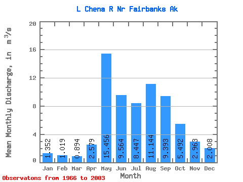
| Statistic | Jan | Feb | Mar | Apr | May | Jun | Jul | Aug | Sep | Oct | Nov | Dec | Annual |
|---|---|---|---|---|---|---|---|---|---|---|---|---|---|
| Mean | 1.35 | 1.02 | 0.89 | 2.58 | 15.46 | 9.56 | 8.45 | 11.14 | 9.39 | 5.49 | 2.96 | 2.01 | 5.87 |
| Standard Deviation | 0.68 | 0.59 | 0.56 | 1.89 | 8.13 | 5.11 | 3.47 | 9.48 | 5.02 | 2.96 | 1.56 | 1.02 | 1.95 |
| Min | 0.22 | 0.17 | 0.09 | 0.54 | 4.17 | 2.81 | 2.41 | 3.50 | 3.04 | 1.98 | 0.91 | 0.64 | 2.85 |
| Max | 3.17 | 2.12 | 2.04 | 7.64 | 34.46 | 26.40 | 18.82 | 60.80 | 21.88 | 13.87 | 7.49 | 4.98 | 11.96 |
| Coefficient of Variation | 0.50 | 0.58 | 0.63 | 0.73 | 0.53 | 0.53 | 0.41 | 0.85 | 0.54 | 0.54 | 0.53 | 0.51 | 0.33 |
 Return to R-Arctic Net Home Page