|
|
|||||||||||||||||
| Point ID: 9100 | Downloads | Plots | Site Data | Code: 15511000 |
|
|
|||||||||||||||||
| Download | |
|---|---|
| Site Descriptor Information | Site Time Series Data |
| Link to all available data | |
| View: | Time Series | All |
| Units: | m3/s |
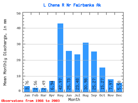
| Statistic | Jan | Feb | Mar | Apr | May | Jun | Jul | Aug | Sep | Oct | Nov | Dec | Annual |
|---|---|---|---|---|---|---|---|---|---|---|---|---|---|
| Mean | 3.76 | 2.58 | 2.48 | 6.94 | 42.96 | 25.73 | 23.48 | 30.97 | 25.27 | 15.27 | 7.97 | 5.58 | 192.22 |
| Standard Deviation | 1.89 | 1.48 | 1.55 | 5.07 | 22.61 | 13.74 | 9.65 | 26.34 | 13.51 | 8.23 | 4.18 | 2.83 | 63.90 |
| Min | 0.62 | 0.43 | 0.25 | 1.46 | 11.60 | 7.55 | 6.69 | 9.74 | 8.17 | 5.49 | 2.44 | 1.77 | 93.48 |
| Max | 8.80 | 5.37 | 5.67 | 20.56 | 95.77 | 71.01 | 52.30 | 168.98 | 58.87 | 38.55 | 20.14 | 13.84 | 391.71 |
| Coefficient of Variation | 0.50 | 0.58 | 0.63 | 0.73 | 0.53 | 0.53 | 0.41 | 0.85 | 0.54 | 0.54 | 0.53 | 0.51 | 0.33 |
 Return to R-Arctic Net Home Page