|
|
|||||||||||||||||
| Point ID: 9099 | Downloads | Plots | Site Data | Code: 139.15.0.1001.1 |
|
|
|||||||||||||||||
| Download | |
|---|---|
| Site Descriptor Information | Site Time Series Data |
| Link to all available data | |
| View: | Time Series | All |
| Units: | mm |
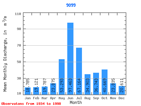
| Statistic | Jan | Feb | Mar | Apr | May | Jun | Jul | Aug | Sep | Oct | Nov | Dec | Annual |
|---|---|---|---|---|---|---|---|---|---|---|---|---|---|
| Mean | 18.79 | 19.12 | 19.79 | 23.88 | 53.29 | 97.46 | 67.16 | 34.90 | 36.74 | 40.67 | 23.84 | 20.61 | 37.77 |
| Standard Deviation | 14.74 | 18.15 | 16.30 | 14.72 | 27.18 | 61.98 | 45.20 | 22.38 | 20.20 | 22.52 | 15.85 | 14.50 | 14.48 |
| Min | 2.52 | 1.69 | 2.65 | 1.97 | 16.50 | 29.74 | 13.07 | 6.92 | 10.90 | 11.04 | 5.04 | 2.84 | 16.52 |
| Max | 63.40 | 96.17 | 72.44 | 79.59 | 162.49 | 253.02 | 190.23 | 96.44 | 107.23 | 108.30 | 77.53 | 70.67 | 75.70 |
| Coefficient of Variation | 0.79 | 0.95 | 0.82 | 0.62 | 0.51 | 0.64 | 0.67 | 0.64 | 0.55 | 0.55 | 0.67 | 0.70 | 0.38 |
 Return to R-Arctic Net Home Page