|
|
|||||||||||||||||
| Point ID: 9099 | Downloads | Plots | Site Data | Code: 139.15.0.1001.1 |
|
|
|||||||||||||||||
| Download | |
|---|---|
| Site Descriptor Information | Site Time Series Data |
| Link to all available data | |
| View: | Time Series | All |
| Units: | m3/s |
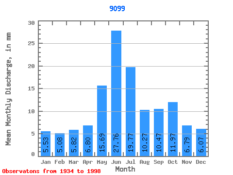
| Statistic | Jan | Feb | Mar | Apr | May | Jun | Jul | Aug | Sep | Oct | Nov | Dec | Annual |
|---|---|---|---|---|---|---|---|---|---|---|---|---|---|
| Mean | 48.51 | 44.99 | 51.10 | 59.68 | 137.63 | 243.61 | 173.45 | 90.14 | 91.84 | 105.02 | 59.58 | 53.23 | 1149.42 |
| Standard Deviation | 38.06 | 42.71 | 42.09 | 36.79 | 70.20 | 154.93 | 116.73 | 57.80 | 50.50 | 58.15 | 39.62 | 37.45 | 440.73 |
| Min | 6.51 | 3.98 | 6.84 | 4.93 | 42.62 | 74.33 | 33.76 | 17.88 | 27.24 | 28.51 | 12.59 | 7.32 | 502.71 |
| Max | 163.73 | 226.27 | 187.07 | 198.94 | 419.63 | 632.42 | 491.25 | 249.06 | 268.03 | 279.68 | 193.79 | 182.51 | 2303.88 |
| Coefficient of Variation | 0.78 | 0.95 | 0.82 | 0.62 | 0.51 | 0.64 | 0.67 | 0.64 | 0.55 | 0.55 | 0.67 | 0.70 | 0.38 |
 Return to R-Arctic Net Home Page