|
|
|||||||||||||||||
| Point ID: 9097 | Downloads | Plots | Site Data | Code: 124.12.0.1001.1 |
|
|
|||||||||||||||||
| Download | |
|---|---|
| Site Descriptor Information | Site Time Series Data |
| Link to all available data | |
| View: | Time Series | All |
| Units: | mm |
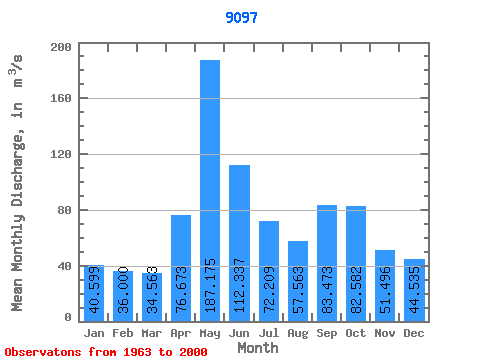
| Statistic | Jan | Feb | Mar | Apr | May | Jun | Jul | Aug | Sep | Oct | Nov | Dec | Annual |
|---|---|---|---|---|---|---|---|---|---|---|---|---|---|
| Mean | 40.60 | 36.00 | 34.56 | 76.67 | 187.18 | 112.34 | 72.21 | 57.56 | 83.47 | 82.58 | 51.50 | 44.53 | 73.27 |
| Standard Deviation | 35.39 | 29.45 | 20.92 | 34.08 | 53.76 | 43.03 | 22.23 | 30.46 | 37.07 | 44.51 | 25.99 | 27.05 | 13.10 |
| Min | 8.47 | 6.60 | 7.50 | 16.83 | 87.05 | 35.22 | 25.80 | 12.77 | 12.70 | 22.43 | 16.57 | 11.07 | 49.17 |
| Max | 155.58 | 144.20 | 82.98 | 139.42 | 335.69 | 222.19 | 120.33 | 127.09 | 169.90 | 204.59 | 111.77 | 147.73 | 98.99 |
| Coefficient of Variation | 0.87 | 0.82 | 0.60 | 0.45 | 0.29 | 0.38 | 0.31 | 0.53 | 0.44 | 0.54 | 0.51 | 0.61 | 0.18 |
 Return to R-Arctic Net Home Page