|
|
|||||||||||||||||
| Point ID: 9093 | Downloads | Plots | Site Data | Code: 196.35.0.1001.1 |
|
|
|||||||||||||||||
| Download | |
|---|---|
| Site Descriptor Information | Site Time Series Data |
| Link to all available data | |
| View: | Time Series | All |
| Units: | mm |
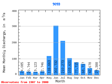
| Statistic | Jan | Feb | Mar | Apr | May | Jun | Jul | Aug | Sep | Oct | Nov | Dec | Annual |
|---|---|---|---|---|---|---|---|---|---|---|---|---|---|
| Mean | 24.09 | 20.74 | 19.12 | 22.75 | 116.66 | 302.73 | 210.27 | 103.63 | 77.72 | 68.72 | 42.68 | 29.39 | 86.31 |
| Standard Deviation | 10.02 | 8.69 | 8.83 | 9.66 | 66.31 | 77.00 | 76.21 | 38.22 | 25.93 | 29.43 | 16.50 | 10.92 | 13.77 |
| Min | 8.38 | 3.68 | 3.03 | 5.17 | 28.70 | 169.70 | 89.17 | 35.21 | 19.58 | 26.25 | 19.09 | 12.70 | 52.75 |
| Max | 54.02 | 65.94 | 60.22 | 46.76 | 356.28 | 543.24 | 448.74 | 211.24 | 195.82 | 160.46 | 92.47 | 72.01 | 124.17 |
| Coefficient of Variation | 0.42 | 0.42 | 0.46 | 0.42 | 0.57 | 0.25 | 0.36 | 0.37 | 0.33 | 0.43 | 0.39 | 0.37 | 0.16 |
 Return to R-Arctic Net Home Page