|
|
|||||||||||||||||
| Point ID: 9067 | Downloads | Plots | Site Data | Code: 49096 |
|
|
|||||||||||||||||
| Download | |
|---|---|
| Site Descriptor Information | Site Time Series Data |
| Link to all available data | |
| View: | Time Series | All |
| Units: | mm |
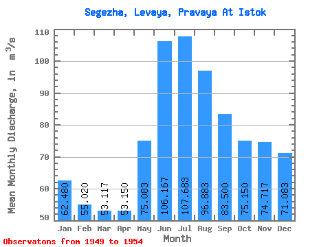
| Statistic | Jan | Feb | Mar | Apr | May | Jun | Jul | Aug | Sep | Oct | Nov | Dec | Annual |
|---|---|---|---|---|---|---|---|---|---|---|---|---|---|
| Mean | 62.48 | 55.02 | 53.12 | 53.15 | 75.08 | 106.17 | 107.68 | 96.88 | 83.50 | 75.15 | 74.72 | 71.08 | 73.58 |
| Standard Deviation | 12.75 | 8.94 | 7.10 | 9.31 | 17.64 | 35.03 | 32.62 | 25.37 | 21.80 | 21.20 | 18.45 | 15.71 | 12.95 |
| Min | 52.00 | 47.10 | 46.30 | 39.90 | 46.50 | 57.30 | 66.30 | 62.40 | 57.50 | 51.90 | 54.30 | 52.00 | 56.61 |
| Max | 83.50 | 70.30 | 64.00 | 64.30 | 90.00 | 162.00 | 164.00 | 130.00 | 106.00 | 95.60 | 96.60 | 96.20 | 92.80 |
| Coefficient of Variation | 0.20 | 0.16 | 0.13 | 0.17 | 0.23 | 0.33 | 0.30 | 0.26 | 0.26 | 0.28 | 0.25 | 0.22 | 0.18 |
 Return to R-Arctic Net Home Page