|
|
|||||||||||||||||
| Point ID: 9067 | Downloads | Plots | Site Data | Code: 49096 |
|
|
|||||||||||||||||
| Download | |
|---|---|
| Site Descriptor Information | Site Time Series Data |
| Link to all available data | |
| View: | Time Series | All |
| Units: | m3/s |
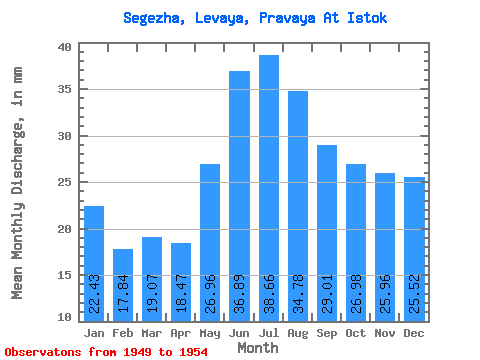
| Statistic | Jan | Feb | Mar | Apr | May | Jun | Jul | Aug | Sep | Oct | Nov | Dec | Annual |
|---|---|---|---|---|---|---|---|---|---|---|---|---|---|
| Mean | 22.43 | 18.00 | 19.07 | 18.47 | 26.95 | 36.89 | 38.66 | 34.78 | 29.01 | 26.98 | 25.96 | 25.52 | 311.31 |
| Standard Deviation | 4.58 | 2.92 | 2.55 | 3.23 | 6.33 | 12.17 | 11.71 | 9.11 | 7.57 | 7.61 | 6.41 | 5.64 | 54.78 |
| Min | 18.67 | 15.40 | 16.62 | 13.86 | 16.69 | 19.91 | 23.80 | 22.40 | 19.98 | 18.63 | 18.87 | 18.67 | 239.49 |
| Max | 29.98 | 22.99 | 22.98 | 22.34 | 32.31 | 56.29 | 58.87 | 46.67 | 36.83 | 34.32 | 33.56 | 34.53 | 392.60 |
| Coefficient of Variation | 0.20 | 0.16 | 0.13 | 0.17 | 0.23 | 0.33 | 0.30 | 0.26 | 0.26 | 0.28 | 0.25 | 0.22 | 0.18 |
 Return to R-Arctic Net Home Page