|
|
|||||||||||||||||
| Point ID: 9063 | Downloads | Plots | Site Data | Code: 49082 |
|
|
|||||||||||||||||
| Download | |
|---|---|
| Site Descriptor Information | Site Time Series Data |
| Link to all available data | |
| View: | Time Series | All |
| Units: | mm |
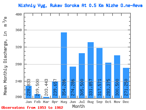
| Statistic | Jan | Feb | Mar | Apr | May | Jun | Jul | Aug | Sep | Oct | Nov | Dec | Annual |
|---|---|---|---|---|---|---|---|---|---|---|---|---|---|
| Mean | 228.83 | 209.50 | 203.44 | 239.66 | 354.29 | 274.29 | 305.50 | 331.86 | 317.57 | 283.38 | 300.50 | 271.25 | 289.73 |
| Standard Deviation | 70.16 | 69.44 | 147.76 | 167.43 | 205.89 | 119.89 | 227.43 | 200.23 | 137.71 | 120.03 | 114.01 | 89.76 | 121.92 |
| Min | 158.00 | 108.00 | 99.10 | 77.60 | 126.00 | 98.00 | 128.00 | 157.00 | 172.00 | 167.00 | 168.00 | 148.00 | 155.92 |
| Max | 346.00 | 273.00 | 510.00 | 480.00 | 743.00 | 440.00 | 755.00 | 692.00 | 563.00 | 512.00 | 512.00 | 413.00 | 457.33 |
| Coefficient of Variation | 0.31 | 0.33 | 0.73 | 0.70 | 0.58 | 0.44 | 0.74 | 0.60 | 0.43 | 0.42 | 0.38 | 0.33 | 0.42 |
 Return to R-Arctic Net Home Page