|
|
|||||||||||||||||
| Point ID: 9063 | Downloads | Plots | Site Data | Code: 49082 |
|
|
|||||||||||||||||
| Download | |
|---|---|
| Site Descriptor Information | Site Time Series Data |
| Link to all available data | |
| View: | Time Series | All |
| Units: | m3/s |
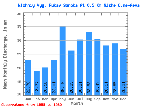
| Statistic | Jan | Feb | Mar | Apr | May | Jun | Jul | Aug | Sep | Oct | Nov | Dec | Annual |
|---|---|---|---|---|---|---|---|---|---|---|---|---|---|
| Mean | 22.70 | 18.93 | 20.18 | 23.01 | 35.14 | 26.33 | 30.30 | 32.91 | 30.49 | 28.11 | 28.85 | 26.90 | 338.67 |
| Standard Deviation | 6.96 | 6.28 | 14.66 | 16.07 | 20.42 | 11.51 | 22.56 | 19.86 | 13.22 | 11.90 | 10.95 | 8.90 | 142.51 |
| Min | 15.67 | 9.76 | 9.83 | 7.45 | 12.50 | 9.41 | 12.70 | 15.57 | 16.51 | 16.56 | 16.13 | 14.68 | 182.25 |
| Max | 34.32 | 24.67 | 50.58 | 46.08 | 73.69 | 42.24 | 74.89 | 68.64 | 54.05 | 50.78 | 49.15 | 40.96 | 534.57 |
| Coefficient of Variation | 0.31 | 0.33 | 0.73 | 0.70 | 0.58 | 0.44 | 0.74 | 0.60 | 0.43 | 0.42 | 0.38 | 0.33 | 0.42 |
 Return to R-Arctic Net Home Page