|
|
|||||||||||||||||
| Point ID: 9052 | Downloads | Plots | Site Data | Code: 49016 |
|
|
|||||||||||||||||
| Download | |
|---|---|
| Site Descriptor Information | Site Time Series Data |
| Link to all available data | |
| View: | Time Series | All |
| Units: | mm |
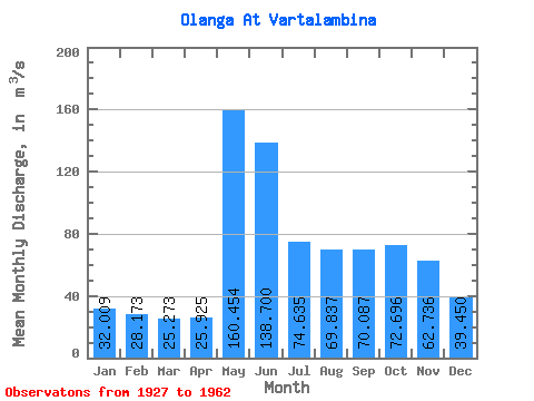
| Statistic | Jan | Feb | Mar | Apr | May | Jun | Jul | Aug | Sep | Oct | Nov | Dec | Annual |
|---|---|---|---|---|---|---|---|---|---|---|---|---|---|
| Mean | 32.01 | 28.17 | 25.27 | 25.93 | 160.45 | 138.70 | 74.64 | 69.84 | 70.09 | 72.70 | 62.74 | 39.45 | 63.52 |
| Standard Deviation | 8.68 | 7.43 | 6.34 | 10.50 | 49.91 | 55.99 | 29.45 | 30.83 | 32.70 | 39.48 | 25.33 | 11.71 | 14.88 |
| Min | 19.60 | 16.90 | 17.10 | 15.90 | 57.00 | 66.90 | 32.30 | 22.80 | 21.80 | 26.50 | 19.70 | 21.10 | 38.36 |
| Max | 45.50 | 40.20 | 35.90 | 52.50 | 252.00 | 265.00 | 127.00 | 114.00 | 132.00 | 202.00 | 113.00 | 52.50 | 86.02 |
| Coefficient of Variation | 0.27 | 0.26 | 0.25 | 0.41 | 0.31 | 0.40 | 0.40 | 0.44 | 0.47 | 0.54 | 0.40 | 0.30 | 0.23 |
 Return to R-Arctic Net Home Page