|
|
|||||||||||||||||
| Point ID: 9052 | Downloads | Plots | Site Data | Code: 49016 |
|
|
|||||||||||||||||
| Download | |
|---|---|
| Site Descriptor Information | Site Time Series Data |
| Link to all available data | |
| View: | Time Series | All |
| Units: | m3/s |
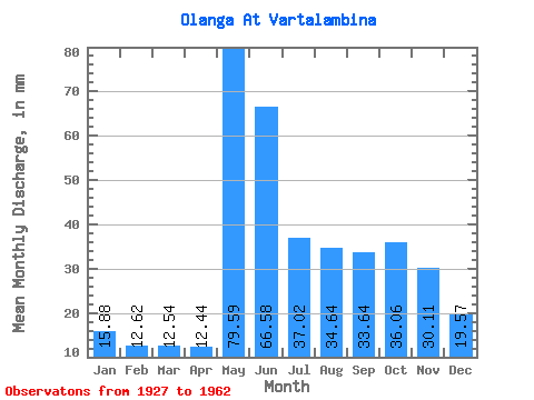
| Statistic | Jan | Feb | Mar | Apr | May | Jun | Jul | Aug | Sep | Oct | Nov | Dec | Annual |
|---|---|---|---|---|---|---|---|---|---|---|---|---|---|
| Mean | 15.87 | 12.73 | 12.53 | 12.44 | 79.57 | 66.58 | 37.01 | 34.63 | 33.64 | 36.05 | 30.11 | 19.56 | 371.23 |
| Standard Deviation | 4.30 | 3.36 | 3.14 | 5.04 | 24.75 | 26.88 | 14.60 | 15.29 | 15.70 | 19.58 | 12.16 | 5.81 | 86.97 |
| Min | 9.72 | 7.64 | 8.48 | 7.63 | 28.27 | 32.11 | 16.02 | 11.31 | 10.46 | 13.14 | 9.46 | 10.46 | 224.18 |
| Max | 22.57 | 18.16 | 17.80 | 25.20 | 124.97 | 127.20 | 62.98 | 56.54 | 63.36 | 100.18 | 54.24 | 26.04 | 502.72 |
| Coefficient of Variation | 0.27 | 0.26 | 0.25 | 0.41 | 0.31 | 0.40 | 0.40 | 0.44 | 0.47 | 0.54 | 0.40 | 0.30 | 0.23 |
 Return to R-Arctic Net Home Page