|
|
|||||||||||||||||
| Point ID: 9044 | Downloads | Plots | Site Data | Code: 71287 |
|
|
|||||||||||||||||
| Download | |
|---|---|
| Site Descriptor Information | Site Time Series Data |
| Link to all available data | |
| View: | Time Series | All |
| Units: | mm |
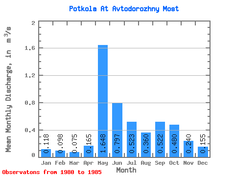
| Statistic | Jan | Feb | Mar | Apr | May | Jun | Jul | Aug | Sep | Oct | Nov | Dec | Annual |
|---|---|---|---|---|---|---|---|---|---|---|---|---|---|
| Mean | 0.12 | 0.10 | 0.07 | 0.17 | 1.65 | 0.80 | 0.52 | 0.36 | 0.52 | 0.48 | 0.24 | 0.15 | 0.43 |
| Standard Deviation | 0.04 | 0.04 | 0.04 | 0.16 | 0.57 | 0.32 | 0.32 | 0.11 | 0.26 | 0.16 | 0.08 | 0.05 | 0.08 |
| Min | 0.06 | 0.05 | 0.01 | 0.00 | 0.87 | 0.40 | 0.21 | 0.23 | 0.31 | 0.25 | 0.12 | 0.08 | 0.32 |
| Max | 0.16 | 0.13 | 0.11 | 0.48 | 2.57 | 1.20 | 0.88 | 0.50 | 1.00 | 0.65 | 0.33 | 0.22 | 0.52 |
| Coefficient of Variation | 0.34 | 0.39 | 0.55 | 0.99 | 0.35 | 0.40 | 0.61 | 0.32 | 0.49 | 0.33 | 0.34 | 0.30 | 0.18 |
 Return to R-Arctic Net Home Page