|
|
|||||||||||||||||
| Point ID: 9044 | Downloads | Plots | Site Data | Code: 71287 |
|
|
|||||||||||||||||
| Download | |
|---|---|
| Site Descriptor Information | Site Time Series Data |
| Link to all available data | |
| View: | Time Series | All |
| Units: | m3/s |
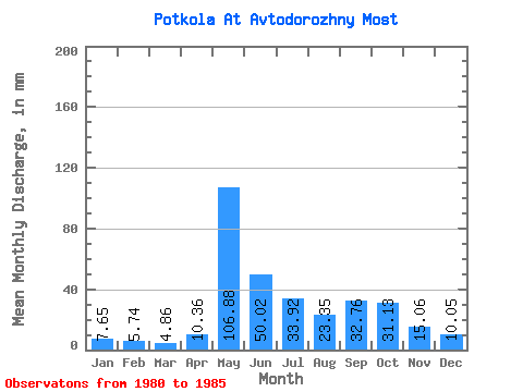
| Statistic | Jan | Feb | Mar | Apr | May | Jun | Jul | Aug | Sep | Oct | Nov | Dec | Annual |
|---|---|---|---|---|---|---|---|---|---|---|---|---|---|
| Mean | 7.67 | 5.81 | 4.86 | 10.36 | 106.88 | 50.00 | 33.93 | 23.34 | 32.74 | 31.12 | 15.06 | 10.05 | 329.97 |
| Standard Deviation | 2.58 | 2.25 | 2.68 | 10.22 | 37.19 | 20.15 | 20.83 | 7.38 | 16.17 | 10.13 | 5.19 | 2.98 | 61.11 |
| Min | 3.89 | 2.95 | 0.65 | 0.00 | 56.41 | 25.10 | 13.62 | 14.91 | 19.46 | 16.21 | 7.53 | 5.19 | 245.17 |
| Max | 10.38 | 7.68 | 7.13 | 30.12 | 166.65 | 75.31 | 57.06 | 32.42 | 62.76 | 42.15 | 20.71 | 14.27 | 398.00 |
| Coefficient of Variation | 0.34 | 0.39 | 0.55 | 0.99 | 0.35 | 0.40 | 0.61 | 0.32 | 0.49 | 0.33 | 0.34 | 0.30 | 0.18 |
 Return to R-Arctic Net Home Page