|
|
|||||||||||||||||
| Point ID: 903 | Downloads | Plots | Site Data | Code: 07FD015 |
|
|
|||||||||||||||||
| Download | |
|---|---|
| Site Descriptor Information | Site Time Series Data |
| Link to all available data | |
| View: | Time Series | All |
| Units: | mm |
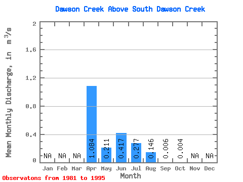
| Statistic | Jan | Feb | Mar | Apr | May | Jun | Jul | Aug | Sep | Oct | Nov | Dec | Annual |
|---|---|---|---|---|---|---|---|---|---|---|---|---|---|
| Mean | 1.08 | 0.21 | 0.42 | 0.28 | 0.15 | 0.01 | 0.00 | ||||||
| Standard Deviation | 0.44 | 0.27 | 1.05 | 0.68 | 0.38 | 0.01 | 0.01 | ||||||
| Min | 0.70 | 0.01 | 0.00 | 0.00 | 0.00 | 0.00 | 0.00 | ||||||
| Max | 1.77 | 0.83 | 3.82 | 2.47 | 1.38 | 0.04 | 0.01 | ||||||
| Coefficient of Variation | 0.40 | 1.30 | 2.52 | 2.45 | 2.61 | 1.82 | 1.44 |
 Return to R-Arctic Net Home Page