|
|
|||||||||||||||||
| Point ID: 903 | Downloads | Plots | Site Data | Code: 07FD015 |
|
|
|||||||||||||||||
| Download | |
|---|---|
| Site Descriptor Information | Site Time Series Data |
| Link to all available data | |
| View: | Time Series | All |
| Units: | m3/s |
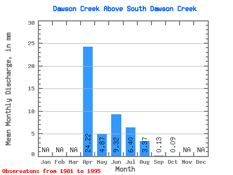
| Statistic | Jan | Feb | Mar | Apr | May | Jun | Jul | Aug | Sep | Oct | Nov | Dec | Annual |
|---|---|---|---|---|---|---|---|---|---|---|---|---|---|
| Mean | 24.21 | 4.87 | 9.31 | 6.40 | 3.37 | 0.14 | 0.09 | ||||||
| Standard Deviation | 9.75 | 6.31 | 23.43 | 15.66 | 8.78 | 0.25 | 0.13 | ||||||
| Min | 15.60 | 0.14 | 0.00 | 0.02 | 0.00 | 0.00 | 0.00 | ||||||
| Max | 39.55 | 19.21 | 85.36 | 57.02 | 31.86 | 0.94 | 0.32 | ||||||
| Coefficient of Variation | 0.40 | 1.30 | 2.52 | 2.45 | 2.61 | 1.82 | 1.44 |
 Return to R-Arctic Net Home Page