|
|
|||||||||||||||||
| Point ID: 902 | Downloads | Plots | Site Data | Code: 07FD010 |
|
|
|||||||||||||||||
| Download | |
|---|---|
| Site Descriptor Information | Site Time Series Data |
| Link to all available data | |
| View: | Time Series | All |
| Units: | mm |
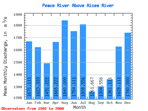
| Statistic | Jan | Feb | Mar | Apr | May | Jun | Jul | Aug | Sep | Oct | Nov | Dec | Annual |
|---|---|---|---|---|---|---|---|---|---|---|---|---|---|
| Mean | 1671.11 | 1623.33 | 1491.22 | 1665.22 | 1840.00 | 1754.11 | 1808.56 | 1261.67 | 1304.56 | 1361.11 | 1628.11 | 1740.00 | 1595.75 |
| Standard Deviation | 163.89 | 258.07 | 248.07 | 404.81 | 497.75 | 785.41 | 1714.58 | 702.09 | 393.26 | 183.95 | 338.09 | 168.82 | 317.29 |
| Min | 1450.00 | 1200.00 | 911.00 | 937.00 | 1090.00 | 987.00 | 807.00 | 755.00 | 721.00 | 1070.00 | 943.00 | 1480.00 | 1163.67 |
| Max | 1930.00 | 1900.00 | 1730.00 | 2170.00 | 2690.00 | 3520.00 | 6340.00 | 3080.00 | 2200.00 | 1690.00 | 2040.00 | 2040.00 | 2334.17 |
| Coefficient of Variation | 0.10 | 0.16 | 0.17 | 0.24 | 0.27 | 0.45 | 0.95 | 0.56 | 0.30 | 0.14 | 0.21 | 0.10 | 0.20 |
 Return to R-Arctic Net Home Page