|
|
|||||||||||||||||
| Point ID: 902 | Downloads | Plots | Site Data | Code: 07FD010 |
|
|
|||||||||||||||||
| Download | |
|---|---|
| Site Descriptor Information | Site Time Series Data |
| Link to all available data | |
| View: | Time Series | All |
| Units: | m3/s |
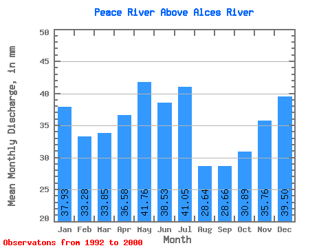
| Statistic | Jan | Feb | Mar | Apr | May | Jun | Jul | Aug | Sep | Oct | Nov | Dec | Annual |
|---|---|---|---|---|---|---|---|---|---|---|---|---|---|
| Mean | 37.93 | 33.57 | 33.84 | 36.58 | 41.76 | 38.53 | 41.05 | 28.63 | 28.66 | 30.89 | 35.76 | 39.49 | 426.80 |
| Standard Deviation | 3.72 | 5.34 | 5.63 | 8.89 | 11.30 | 17.25 | 38.91 | 15.93 | 8.64 | 4.17 | 7.43 | 3.83 | 84.86 |
| Min | 32.91 | 24.81 | 20.68 | 20.58 | 24.74 | 21.68 | 18.32 | 17.14 | 15.84 | 24.28 | 20.71 | 33.59 | 311.23 |
| Max | 43.80 | 39.29 | 39.26 | 47.67 | 61.05 | 77.32 | 143.89 | 69.90 | 48.33 | 38.35 | 44.81 | 46.30 | 624.29 |
| Coefficient of Variation | 0.10 | 0.16 | 0.17 | 0.24 | 0.27 | 0.45 | 0.95 | 0.56 | 0.30 | 0.14 | 0.21 | 0.10 | 0.20 |
 Return to R-Arctic Net Home Page