|
|
|||||||||||||||||
| Point ID: 8999 | Downloads | Plots | Site Data | Code: 71149 |
|
|
|||||||||||||||||
| Download | |
|---|---|
| Site Descriptor Information | Site Time Series Data |
| Link to all available data | |
| View: | Time Series | All |
| Units: | mm |
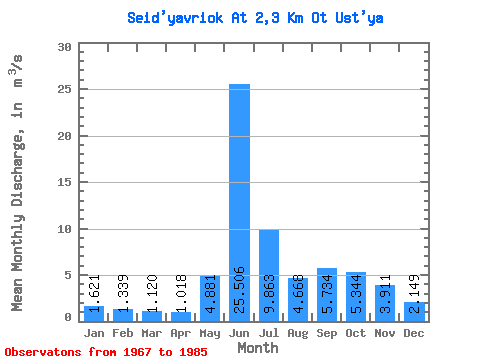
| Statistic | Jan | Feb | Mar | Apr | May | Jun | Jul | Aug | Sep | Oct | Nov | Dec | Annual |
|---|---|---|---|---|---|---|---|---|---|---|---|---|---|
| Mean | 1.62 | 1.34 | 1.12 | 1.02 | 4.88 | 25.51 | 9.86 | 4.67 | 5.73 | 5.34 | 3.91 | 2.15 | 4.90 |
| Standard Deviation | 0.16 | 0.15 | 0.19 | 0.11 | 4.00 | 34.42 | 5.06 | 1.41 | 1.85 | 2.87 | 1.91 | 0.46 | 0.51 |
| Min | 1.46 | 1.08 | 0.87 | 0.84 | 1.36 | 11.10 | 5.12 | 2.57 | 3.12 | 2.62 | 2.15 | 1.69 | 4.11 |
| Max | 1.89 | 1.56 | 1.49 | 1.19 | 14.50 | 154.00 | 25.70 | 6.88 | 9.84 | 13.30 | 7.68 | 2.90 | 5.54 |
| Coefficient of Variation | 0.10 | 0.11 | 0.17 | 0.11 | 0.82 | 1.35 | 0.51 | 0.30 | 0.32 | 0.54 | 0.49 | 0.21 | 0.10 |
 Return to R-Arctic Net Home Page