|
|
|||||||||||||||||
| Point ID: 8999 | Downloads | Plots | Site Data | Code: 71149 |
|
|
|||||||||||||||||
| Download | |
|---|---|
| Site Descriptor Information | Site Time Series Data |
| Link to all available data | |
| View: | Time Series | All |
| Units: | m3/s |
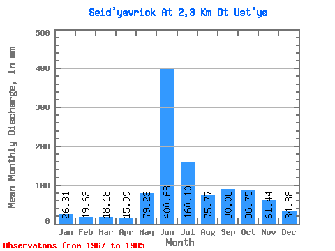
| Statistic | Jan | Feb | Mar | Apr | May | Jun | Jul | Aug | Sep | Oct | Nov | Dec | Annual |
|---|---|---|---|---|---|---|---|---|---|---|---|---|---|
| Mean | 26.32 | 19.80 | 18.18 | 15.98 | 79.22 | 400.68 | 160.08 | 75.76 | 90.08 | 86.74 | 61.44 | 34.88 | 937.15 |
| Standard Deviation | 2.59 | 2.26 | 3.07 | 1.71 | 64.91 | 540.65 | 82.16 | 22.90 | 29.14 | 46.65 | 30.04 | 7.50 | 97.88 |
| Min | 23.70 | 15.97 | 14.12 | 13.20 | 22.07 | 174.37 | 83.10 | 41.71 | 49.01 | 42.52 | 33.77 | 27.43 | 785.33 |
| Max | 30.68 | 23.07 | 24.18 | 18.69 | 235.34 | 2419.20 | 417.12 | 111.66 | 154.58 | 215.86 | 120.66 | 47.07 | 1059.82 |
| Coefficient of Variation | 0.10 | 0.11 | 0.17 | 0.11 | 0.82 | 1.35 | 0.51 | 0.30 | 0.32 | 0.54 | 0.49 | 0.21 | 0.10 |
 Return to R-Arctic Net Home Page