|
|
|||||||||||||||||
| Point ID: 8979 | Downloads | Plots | Site Data | Code: 71097 |
|
|
|||||||||||||||||
| Download | |
|---|---|
| Site Descriptor Information | Site Time Series Data |
| Link to all available data | |
| View: | Time Series | All |
| Units: | mm |
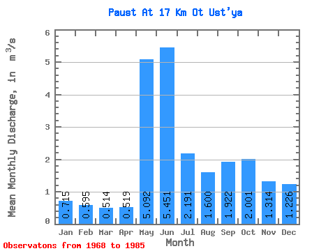
| Statistic | Jan | Feb | Mar | Apr | May | Jun | Jul | Aug | Sep | Oct | Nov | Dec | Annual |
|---|---|---|---|---|---|---|---|---|---|---|---|---|---|
| Mean | 0.71 | 0.59 | 0.51 | 0.52 | 5.09 | 5.45 | 2.19 | 1.60 | 1.92 | 2.00 | 1.31 | 1.23 | 1.93 |
| Standard Deviation | 0.13 | 0.09 | 0.09 | 0.12 | 2.81 | 2.30 | 1.30 | 0.83 | 0.78 | 0.67 | 0.30 | 1.37 | 0.41 |
| Min | 0.49 | 0.39 | 0.33 | 0.40 | 1.13 | 2.35 | 1.07 | 0.69 | 0.75 | 1.10 | 0.87 | 0.62 | 1.40 |
| Max | 0.91 | 0.74 | 0.68 | 0.84 | 10.40 | 9.77 | 5.09 | 3.59 | 3.42 | 3.31 | 1.94 | 6.70 | 2.53 |
| Coefficient of Variation | 0.18 | 0.15 | 0.18 | 0.23 | 0.55 | 0.42 | 0.60 | 0.52 | 0.40 | 0.33 | 0.23 | 1.12 | 0.21 |
 Return to R-Arctic Net Home Page