|
|
|||||||||||||||||
| Point ID: 8979 | Downloads | Plots | Site Data | Code: 71097 |
|
|
|||||||||||||||||
| Download | |
|---|---|
| Site Descriptor Information | Site Time Series Data |
| Link to all available data | |
| View: | Time Series | All |
| Units: | m3/s |
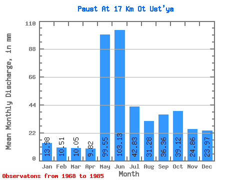
| Statistic | Jan | Feb | Mar | Apr | May | Jun | Jul | Aug | Sep | Oct | Nov | Dec | Annual |
|---|---|---|---|---|---|---|---|---|---|---|---|---|---|
| Mean | 13.97 | 10.59 | 10.06 | 9.82 | 99.53 | 103.13 | 42.82 | 31.28 | 36.36 | 39.12 | 24.86 | 23.96 | 444.72 |
| Standard Deviation | 2.48 | 1.59 | 1.82 | 2.24 | 54.95 | 43.45 | 25.51 | 16.23 | 14.70 | 13.08 | 5.72 | 26.85 | 95.02 |
| Min | 9.58 | 6.95 | 6.45 | 7.57 | 22.09 | 44.46 | 20.92 | 13.49 | 14.19 | 21.50 | 16.46 | 12.12 | 322.13 |
| Max | 17.79 | 13.18 | 13.29 | 15.89 | 203.29 | 184.85 | 99.50 | 70.17 | 64.70 | 64.70 | 36.70 | 130.97 | 582.63 |
| Coefficient of Variation | 0.18 | 0.15 | 0.18 | 0.23 | 0.55 | 0.42 | 0.60 | 0.52 | 0.40 | 0.33 | 0.23 | 1.12 | 0.21 |
 Return to R-Arctic Net Home Page