|
|
|||||||||||||||||
| Point ID: 8978 | Downloads | Plots | Site Data | Code: 71096 |
|
|
|||||||||||||||||
| Download | |
|---|---|
| Site Descriptor Information | Site Time Series Data |
| Link to all available data | |
| View: | Time Series | All |
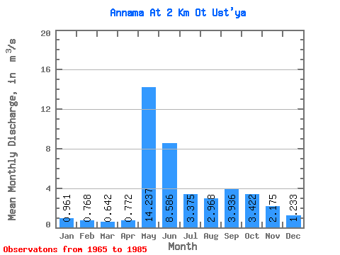
| Units: | mm |
| Statistic | Jan | Feb | Mar | Apr | May | Jun | Jul | Aug | Sep | Oct | Nov | Dec | Annual |
|---|---|---|---|---|---|---|---|---|---|---|---|---|---|
| Mean | 0.96 | 0.77 | 0.64 | 0.77 | 14.24 | 8.59 | 3.38 | 2.97 | 3.94 | 3.42 | 2.17 | 1.23 | 3.55 |
| Standard Deviation | 0.19 | 0.17 | 0.17 | 0.44 | 6.33 | 4.75 | 1.98 | 1.56 | 1.65 | 1.21 | 1.45 | 0.23 | 0.78 |
| Min | 0.57 | 0.43 | 0.35 | 0.38 | 2.94 | 2.94 | 1.39 | 1.32 | 1.54 | 1.68 | 1.11 | 0.80 | 2.19 |
| Max | 1.37 | 1.17 | 0.94 | 2.42 | 25.70 | 19.00 | 8.34 | 7.43 | 7.42 | 6.35 | 7.96 | 1.56 | 4.94 |
| Coefficient of Variation | 0.20 | 0.22 | 0.27 | 0.57 | 0.44 | 0.55 | 0.59 | 0.53 | 0.42 | 0.35 | 0.67 | 0.19 | 0.22 |
 Return to R-Arctic Net Home Page