|
|
|||||||||||||||||
| Point ID: 8978 | Downloads | Plots | Site Data | Code: 71096 |
|
|
|||||||||||||||||
| Download | |
|---|---|
| Site Descriptor Information | Site Time Series Data |
| Link to all available data | |
| View: | Time Series | All |
| Units: | m3/s |
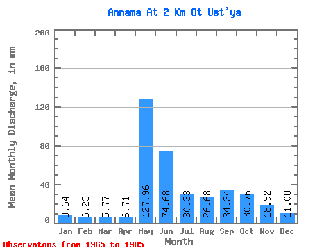
| Statistic | Jan | Feb | Mar | Apr | May | Jun | Jul | Aug | Sep | Oct | Nov | Dec | Annual |
|---|---|---|---|---|---|---|---|---|---|---|---|---|---|
| Mean | 8.64 | 6.28 | 5.77 | 6.72 | 127.95 | 74.68 | 30.33 | 26.67 | 34.24 | 30.75 | 18.92 | 11.08 | 376.23 |
| Standard Deviation | 1.71 | 1.40 | 1.53 | 3.80 | 56.87 | 41.35 | 17.78 | 14.00 | 14.32 | 10.84 | 12.65 | 2.08 | 82.39 |
| Min | 5.12 | 3.52 | 3.15 | 3.31 | 26.42 | 25.57 | 12.49 | 11.86 | 13.39 | 15.10 | 9.65 | 7.19 | 231.76 |
| Max | 12.31 | 9.58 | 8.45 | 21.05 | 230.96 | 165.26 | 74.95 | 66.77 | 64.54 | 57.07 | 69.24 | 14.02 | 522.91 |
| Coefficient of Variation | 0.20 | 0.22 | 0.27 | 0.57 | 0.44 | 0.55 | 0.59 | 0.53 | 0.42 | 0.35 | 0.67 | 0.19 | 0.22 |
 Return to R-Arctic Net Home Page