|
|
|||||||||||||||||
| Point ID: 8969 | Downloads | Plots | Site Data | Code: 71079 |
|
|
|||||||||||||||||
| Download | |
|---|---|
| Site Descriptor Information | Site Time Series Data |
| Link to all available data | |
| View: | Time Series | All |
| Units: | mm |
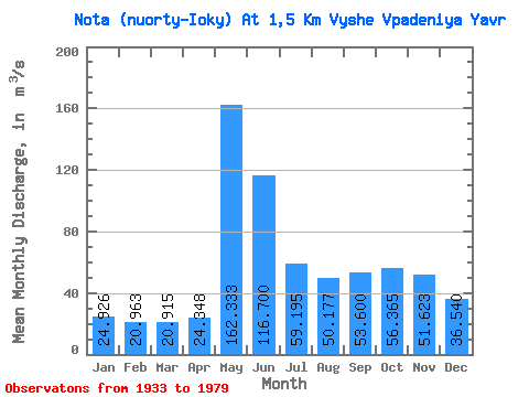
| Statistic | Jan | Feb | Mar | Apr | May | Jun | Jul | Aug | Sep | Oct | Nov | Dec | Annual |
|---|---|---|---|---|---|---|---|---|---|---|---|---|---|
| Mean | 24.93 | 20.96 | 20.91 | 24.35 | 162.33 | 116.70 | 59.20 | 50.18 | 53.60 | 56.37 | 51.62 | 36.54 | 66.34 |
| Standard Deviation | 12.46 | 10.48 | 11.68 | 17.10 | 87.55 | 99.06 | 42.83 | 35.85 | 39.41 | 35.37 | 36.07 | 19.81 | 32.17 |
| Min | 7.48 | 7.09 | 6.99 | 6.34 | 23.90 | 20.30 | 17.20 | 14.50 | 13.00 | 9.57 | 8.31 | 9.23 | 15.65 |
| Max | 43.90 | 35.00 | 46.20 | 62.10 | 313.00 | 327.00 | 137.00 | 132.00 | 175.00 | 126.00 | 118.00 | 74.50 | 116.17 |
| Coefficient of Variation | 0.50 | 0.50 | 0.56 | 0.70 | 0.54 | 0.85 | 0.72 | 0.71 | 0.73 | 0.63 | 0.70 | 0.54 | 0.48 |
 Return to R-Arctic Net Home Page