|
|
|||||||||||||||||
| Point ID: 8969 | Downloads | Plots | Site Data | Code: 71079 |
|
|
|||||||||||||||||
| Download | |
|---|---|
| Site Descriptor Information | Site Time Series Data |
| Link to all available data | |
| View: | Time Series | All |
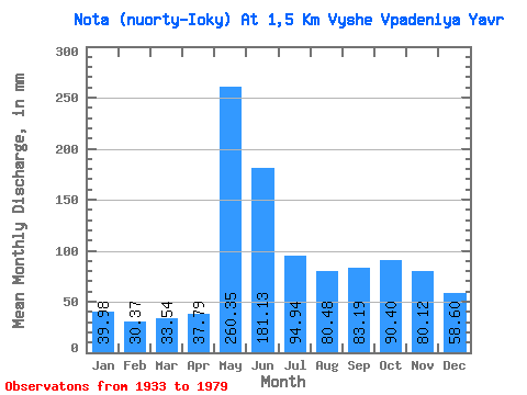
| Units: | m3/s |
| Statistic | Jan | Feb | Mar | Apr | May | Jun | Jul | Aug | Sep | Oct | Nov | Dec | Annual |
|---|---|---|---|---|---|---|---|---|---|---|---|---|---|
| Mean | 39.97 | 30.63 | 33.54 | 37.79 | 260.32 | 181.13 | 94.92 | 80.46 | 83.19 | 90.39 | 80.12 | 58.59 | 1253.64 |
| Standard Deviation | 19.98 | 15.31 | 18.72 | 26.55 | 140.39 | 153.76 | 68.67 | 57.49 | 61.16 | 56.72 | 55.98 | 31.76 | 607.93 |
| Min | 12.00 | 10.36 | 11.21 | 9.84 | 38.33 | 31.51 | 27.58 | 23.25 | 20.18 | 15.35 | 12.90 | 14.80 | 295.68 |
| Max | 70.40 | 51.14 | 74.09 | 96.39 | 501.93 | 507.54 | 219.69 | 211.67 | 271.62 | 202.05 | 183.15 | 119.47 | 2195.34 |
| Coefficient of Variation | 0.50 | 0.50 | 0.56 | 0.70 | 0.54 | 0.85 | 0.72 | 0.71 | 0.73 | 0.63 | 0.70 | 0.54 | 0.48 |
 Return to R-Arctic Net Home Page