|
|
|||||||||||||||||
| Point ID: 8928 | Downloads | Plots | Site Data | Code: 70597 |
|
|
|||||||||||||||||
| Download | |
|---|---|
| Site Descriptor Information | Site Time Series Data |
| Link to all available data | |
| View: | Time Series | All |
| Units: | mm |
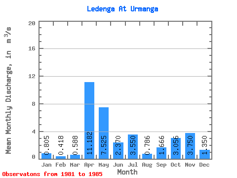
| Statistic | Jan | Feb | Mar | Apr | May | Jun | Jul | Aug | Sep | Oct | Nov | Dec | Annual |
|---|---|---|---|---|---|---|---|---|---|---|---|---|---|
| Mean | 0.81 | 0.42 | 0.59 | 11.18 | 7.53 | 2.37 | 3.55 | 0.79 | 1.67 | 3.06 | 3.75 | 1.35 | 3.26 |
| Standard Deviation | 0.58 | 0.27 | 0.45 | 5.75 | 4.14 | 1.47 | 3.04 | 0.44 | 1.13 | 2.23 | 3.11 | 0.97 | 0.18 |
| Min | 0.25 | 0.18 | 0.17 | 4.68 | 1.83 | 0.41 | 1.66 | 0.31 | 0.26 | 0.48 | 0.70 | 0.36 | 3.10 |
| Max | 1.36 | 0.76 | 1.20 | 17.90 | 11.10 | 3.55 | 8.08 | 1.26 | 3.20 | 5.97 | 8.81 | 2.60 | 3.52 |
| Coefficient of Variation | 0.71 | 0.64 | 0.76 | 0.51 | 0.55 | 0.62 | 0.86 | 0.56 | 0.68 | 0.73 | 0.83 | 0.72 | 0.06 |
 Return to R-Arctic Net Home Page