|
|
|||||||||||||||||
| Point ID: 8928 | Downloads | Plots | Site Data | Code: 70597 |
|
|
|||||||||||||||||
| Download | |
|---|---|
| Site Descriptor Information | Site Time Series Data |
| Link to all available data | |
| View: | Time Series | All |
| Units: | m3/s |
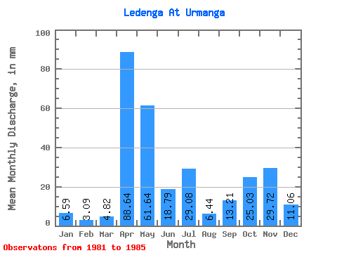
| Statistic | Jan | Feb | Mar | Apr | May | Jun | Jul | Aug | Sep | Oct | Nov | Dec | Annual |
|---|---|---|---|---|---|---|---|---|---|---|---|---|---|
| Mean | 6.59 | 3.12 | 4.81 | 88.64 | 61.63 | 18.79 | 29.07 | 6.44 | 13.21 | 25.03 | 29.73 | 11.06 | 315.04 |
| Standard Deviation | 4.71 | 2.00 | 3.65 | 45.58 | 33.92 | 11.63 | 24.87 | 3.59 | 8.96 | 18.27 | 24.66 | 7.96 | 17.31 |
| Min | 2.05 | 1.34 | 1.39 | 37.10 | 14.99 | 3.25 | 13.60 | 2.54 | 2.06 | 3.93 | 5.55 | 2.95 | 299.43 |
| Max | 11.14 | 5.67 | 9.83 | 141.89 | 90.91 | 28.14 | 66.17 | 10.32 | 25.36 | 48.89 | 69.83 | 21.29 | 339.65 |
| Coefficient of Variation | 0.71 | 0.64 | 0.76 | 0.51 | 0.55 | 0.62 | 0.86 | 0.56 | 0.68 | 0.73 | 0.83 | 0.72 | 0.06 |
 Return to R-Arctic Net Home Page