|
|
|||||||||||||||||
| Point ID: 8925 | Downloads | Plots | Site Data | Code: 70591 |
|
|
|||||||||||||||||
| Download | |
|---|---|
| Site Descriptor Information | Site Time Series Data |
| Link to all available data | |
| View: | Time Series | All |
| Units: | mm |
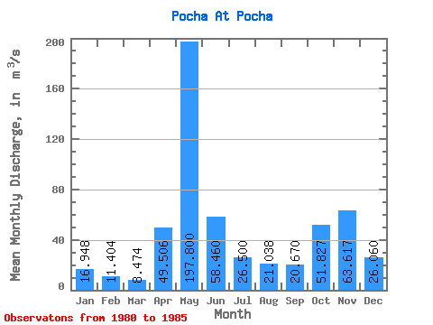
| Statistic | Jan | Feb | Mar | Apr | May | Jun | Jul | Aug | Sep | Oct | Nov | Dec | Annual |
|---|---|---|---|---|---|---|---|---|---|---|---|---|---|
| Mean | 16.95 | 11.40 | 8.47 | 49.51 | 197.80 | 58.46 | 26.50 | 21.04 | 20.67 | 51.83 | 63.62 | 26.06 | 48.89 |
| Standard Deviation | 10.04 | 5.54 | 2.41 | 66.89 | 71.08 | 32.31 | 21.10 | 18.59 | 18.07 | 45.25 | 38.87 | 17.23 | 10.22 |
| Min | 7.11 | 5.45 | 5.94 | 6.16 | 101.00 | 27.20 | 13.20 | 5.19 | 4.11 | 3.96 | 4.30 | 6.86 | 34.54 |
| Max | 30.70 | 18.90 | 12.20 | 167.00 | 265.00 | 111.00 | 68.10 | 54.60 | 54.30 | 117.00 | 106.00 | 55.80 | 58.19 |
| Coefficient of Variation | 0.59 | 0.49 | 0.28 | 1.35 | 0.36 | 0.55 | 0.80 | 0.88 | 0.87 | 0.87 | 0.61 | 0.66 | 0.21 |
 Return to R-Arctic Net Home Page