|
|
|||||||||||||||||
| Point ID: 8925 | Downloads | Plots | Site Data | Code: 70591 |
|
|
|||||||||||||||||
| Download | |
|---|---|
| Site Descriptor Information | Site Time Series Data |
| Link to all available data | |
| View: | Time Series | All |
| Units: | m3/s |
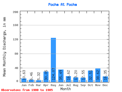
| Statistic | Jan | Feb | Mar | Apr | May | Jun | Jul | Aug | Sep | Oct | Nov | Dec | Annual |
|---|---|---|---|---|---|---|---|---|---|---|---|---|---|
| Mean | 10.63 | 6.52 | 5.32 | 30.05 | 124.05 | 35.49 | 16.62 | 13.20 | 12.55 | 32.50 | 38.62 | 16.34 | 361.38 |
| Standard Deviation | 6.30 | 3.17 | 1.51 | 40.60 | 44.58 | 19.61 | 13.23 | 11.66 | 10.97 | 28.38 | 23.60 | 10.81 | 75.54 |
| Min | 4.46 | 3.12 | 3.73 | 3.74 | 63.34 | 16.51 | 8.28 | 3.25 | 2.50 | 2.48 | 2.61 | 4.30 | 255.29 |
| Max | 19.25 | 10.80 | 7.65 | 101.37 | 166.20 | 67.38 | 42.71 | 34.24 | 32.96 | 73.38 | 64.34 | 35.00 | 430.09 |
| Coefficient of Variation | 0.59 | 0.49 | 0.28 | 1.35 | 0.36 | 0.55 | 0.80 | 0.88 | 0.87 | 0.87 | 0.61 | 0.66 | 0.21 |
 Return to R-Arctic Net Home Page